
Multispectral Digital Data
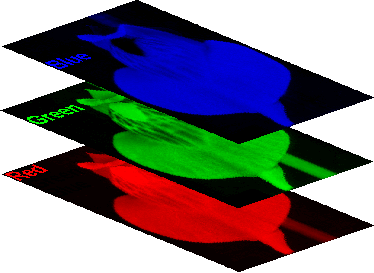 A stack of three images |
Multispectral data can be obtained in a number of ways. A single camera can take a sequence of images, constantly switching in front of the detector one filter after another. Alternately, three or more cameras (each equipped with a different filter) are mounted on a single platform and simultaneously record images. The research team selects which filters are to be used, and their choices are determined by their research goals. A commonly used set of bands in vegetation remote sensing is color-infrared (green, red, and infrared), as described here. In satellite imagery, the available bands are set by the satellite designers before the launch date, and so cannot be modified by the ground-based observers.
Commonly used sources of multispectral imagery includes the Landsat 7 (and archived data from earlier Landsat missions), AVHRR, IKONOS, and SPOT missions.
It is useful to compare this multispectral data stack to the concept of the data-cube on the next page, so glance at that page even if you are not interested in hyperspectral data.