
 (Most of the) Eastern Invasives Network sites
Adirondack Mountains - NY, U.S.A.
The Conservancy's Adirondack Mountains conservation area encompasses roughly the western two-thirds of the six million-acre Adirondack Park in northern New York. This region is a largely unfragmented, forested landscape of spruce-northern hardwood, mountain spruce-fir, and beech-maple-mesic forests. It includes the headwaters of five major drainage basins, 2,800 lakes and ponds, and more than 1,500 miles of rivers.
Priorities and strategies for abatement of invasive plant threats
Measurable goals for reducing invasive species threats and monitoring the success of those efforts
Allegany Forests Project - MD, U.S.A.
The Allegany Forests Project encompasses 150,000 acres in the Central Appalachian Forest Ecoregion. It includes the watersheds of two major tributaries to the upper Potomac River (Sideling Hill and 15-Mile Creeks). The project area includes a matrix forest block (Green Ridge), and incorporates the former Sideling Hill Creek Bioreserve.
Priorities and strategies for abatement of invasive plant threats
Measurable goals for reducing invasive species threats and monitoring the success of those efforts
Invasives inventory
Altamaha River Bioreserve - GA, U.S.A.
The Altamaha River Bioreserve comprises the lower Altamaha River watershed, and falls within the South Atlantic Coastal Plain Ecoregion. It contains a diversity of natural and anthropogenic plant communities, including bottomland hardwood and swamp forests, upland and wetland pine and oak woodlands, and pine plantations. The watershed encompasses over 14,000 square miles, and contains 170,000 acres of floodplain. At almost 90 miles long and up to 6 miles wide, the floodplain of the Altamaha River is one of Georgia's largest contiguous forested wetlands.
Priorities and strategies for abatement of invasive plant threats
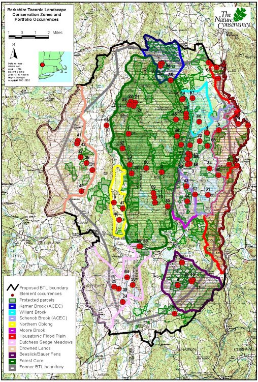
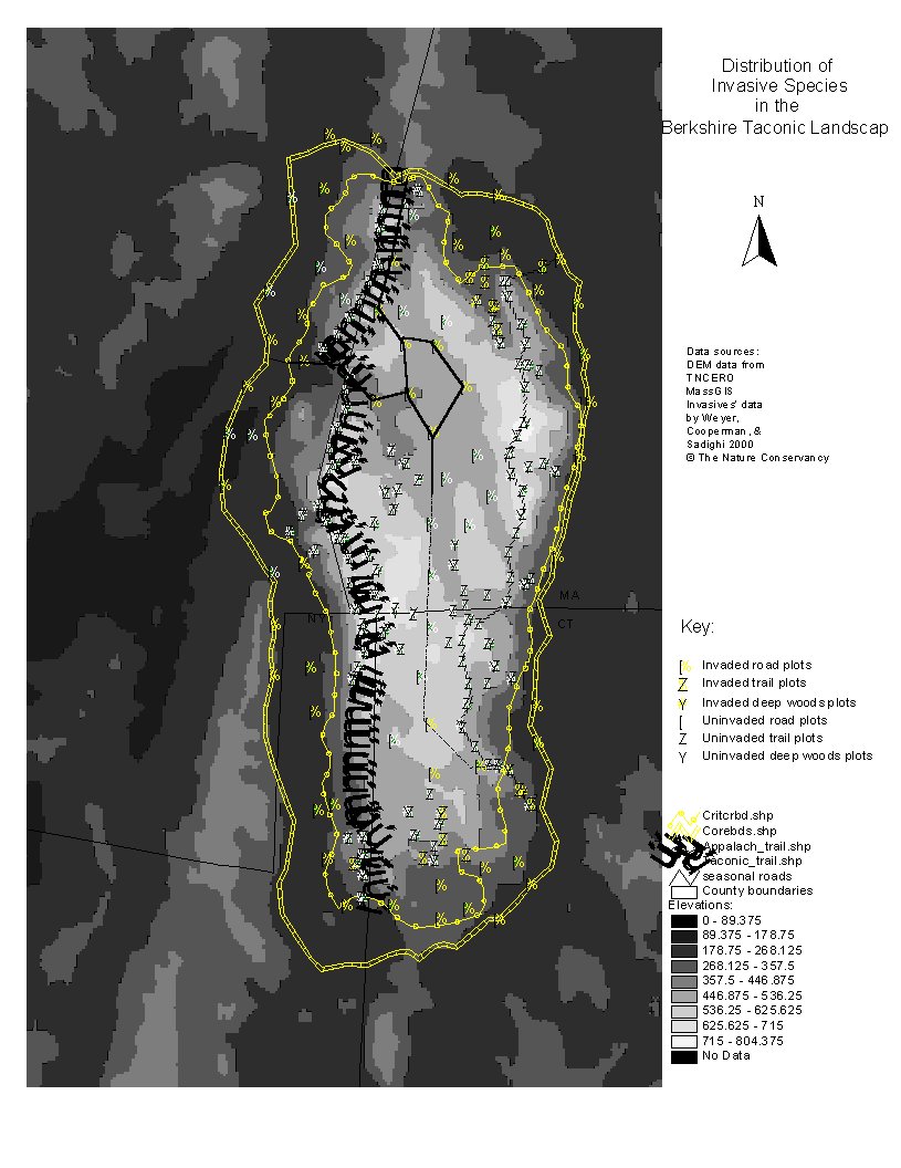
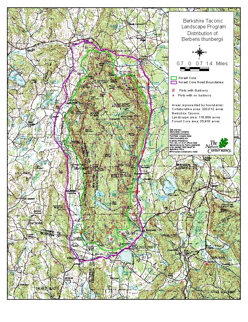
Berkshire Taconic Landscape - MA/NY/CT, U.S.A.
The Berkshire Taconic Landscape is a 116,000-acre region of southwestern New York, western Massachusetts, and northern Connecticut. The landscape includes 36,000 acres of matrix forest and a network of high quality calcareous wetlands. Although remarkably pristine, the project area faces two key threats: inappropriate development and the spread of invasive species.
Desired Future Conditions
Ecological Model: Barberry interactions with forest successional patterns
Ecological Model: Impact of Phragmites australis on composition and structure of successional calcareous seepage wetlands.
Priorities and strategies for abatement of invasive plant threats
Map: conservation zones
Map: invasive species across the landscape.
Map: wetlands invaded by Phragmites australis.
Map: Five-year plan for weed removal.
Map: Phragmites australis in Kampoosa bog.
Map: Distribution of Berberis thunbergii.
Camp Shelby - MS, U.S.A.
The Camp Shelby Training Site (CSTS) is a National Guard Training installation located in southern Mississippi in the East Gulf Coastal Plain Ecoregion. The landscape includes rolling, mesic uplands that support longleaf forests; an open understory of scattered oaks and other hardwoods; and a dense, grass-dominated ground cover. Numerous narrow creeks draining the uplands support wetland communities. TNC's Camp Shelby Field Office provides assistance with endangered and threatened species issues on CSTS as contractors for the Mississippi Army National Guard.
Map: overview
Map: conservation targets
Chesapeake Rivers - VA, U.S.A.
The Chesapeake Rivers project area, totaling roughly 1,800 square miles, encompasses the tidal freshwater portions of the Mattaponi, Pamunkey, and lower Rappahannock river systems as well as the non-tidal blackwater river, Dragon Run. These rivers systems are home to some of the most pristine and extensive tidal freshwater marsh and swamp communities remaining in the coastal plain of the Chesapeake Bay, providing unique habitat for the federally listed, globally rare sensitive joint vetch. The marshes also provide critical nursery habitat for native anadromous fishes and nesting grounds for bald eagles, black ducks, king rails and other resident and migratory waterfowl.
Priorities and strategies for abatement of invasive plant threats
Measurable goals for reducing invasive species threats and monitoring the success of those efforts
Delaware River Watershed - PA, U.S.A.
The Delaware River, the longest free-flowing river in the eastern United States, is 331 miles long and unobstructed by dams or other water control structures. The watershed encompasses over 8 million acres in four states. TNC's PA Chapter is currently working at several landscapes in this region, including the Pocono Plateau, Cherry Valley, and Mt. Bethel Fens. Collectively, these sites protect calcareous fen and wetland complexes, seeps, waterfalls, talus slopes, shale cliffs, till barrens, hemlock ravines, rhododendron swamps, and upland forests dominated by oak and northern hardwoods.
Priorities and strategies for abatement of invasive plant threats
Map: overview
Map: Pennsylvania portion of project area
Map: Portfolio sites in PA portion of project area
Map: Current functional sites in PA portion of project area.
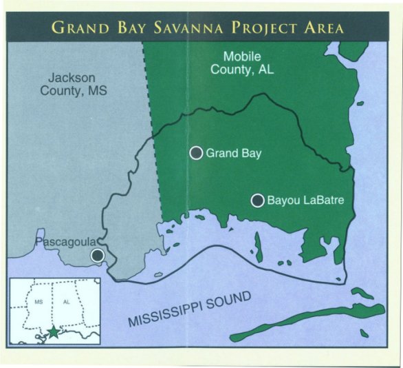
Grand Bay Savanna - AL, U.S.A.
Grand Bay Savanna encompasses over 150,000 acres in southeastern Jackson County, MS and southern Mobile County, AL. The project area includes a mosaic of significant wetland areas separated by agricultural/urban uplands.
Map: overview
Hickory Nut Gorge - NC, U.S.A.
Hickory Nut Gorge encompasses roughly 20,000 acres near Asheville, North Carolina on the edge of the Blue Ridge Escarpment in the Blue Ridge physiographic province. The project area supports 14 natural community types, six of which are considered rare. Also present are extensive, high quality examples of common community types that support rare species, including rich cove forest, pine-oak heath, and chestnut oak forest.
Priorities and strategies for abatement of invasive plant threats
Measurable goals for reducing invasive species threats and monitoring the success of those efforts
Indiana Toleston Strandplain - IN, U.S.A.
The Indiana Toleston Strandplain Macrosite is located within the highly industrialized landscape of northern Lake County, Indiana, and includes fragments of the dune and swale topography that characterized the region prior to European settlement. These remnant natural areas continue to support surprisingly diverse biotic communities that are unique to the Great Lakes basin. The project area is approximately 9,000 acres in size, and includes about 1,000 acres of remnant dune and swale.
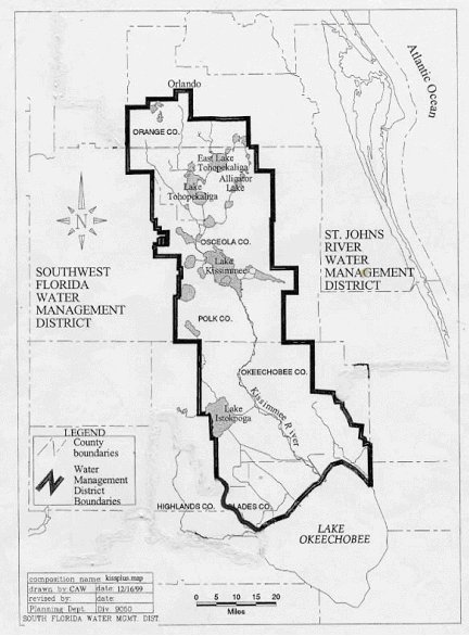
Kissimmee Valley - FL, U.S.A.
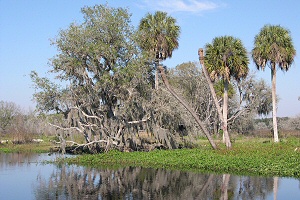 The Kissimmee Valley Landscape Conservation Area occupies approximately 2 million acres in the heart of the Florida
Peninsula Ecoregion, and contains all of the representative natural communities except for coastal communities. The project
area has very high diversity, and contains many rare and endangered species and populations.
The Kissimmee Valley Landscape Conservation Area occupies approximately 2 million acres in the heart of the Florida
Peninsula Ecoregion, and contains all of the representative natural communities except for coastal communities. The project
area has very high diversity, and contains many rare and endangered species and populations.
Ecological Model: Flatwoods matrix
Ecological Model: Lakes
Ecological Model: Kissimmee River tributaries and marshes
Ecological Model: Wetlands
Priorities and strategies for abatement of invasive plant threats
Measurable goals for reducing invasive species threats and monitoring the success of those efforts
Map: overview
Map: restoration project
Milford Neck - DE, U.S.A.
The Milford Neck Conservation Area (MNCA) consists of approximately 10,000 acres of Delaware Bay coastal lands and waters extending north from the Mispillion River to the Murderkill River. Milford Neck contains the entire range of habitat types typically found in coastal areas of the Delaware Bay. These habitats range from high quality beach-dune communities along the shoreline to diverse saltmarsh habitat, narrow-leafed cattail marsh, mixed deciduous swamp forest, loblolly pine forest, mesic mixed upland deciduous forest, and old fields.
Priorities and strategies for abatement of invasive plant threats
Measurable goals for reducing invasive species threats and monitoring the success of those efforts
Quinebaug Highlands - CT, U.S.A.
The Quinebaug Highlands landscape encompasses approximately 172,000 acres in south-central Massachusetts and north-central Connecticut. The project area includes a 34,000-acre block of primary matrix forest that is relatively unfragmented by roads and provides excellent examples of forest types typical of southern New England, including hemlock-northern hardwood, red oak-northern hardwood, and mesic oak.
Measurable goals for reducing invasive species threats and monitoring the success of those efforts
Rolling Fork - KY, U.S.A.
The Salt River/Rolling Fork project area encompasses approximately 500,000 acres in north-central Kentucky. Once a woodland system interspersed with open glades and prairies, the landscape has abundant scattered native stands of tall warm season grasses and forbs, including two federally endangered species. The landscape also includes large blocks of protected forest.
Priorities and strategies for abatement of invasive plant threats
Measurable goals for reducing invasive species threats and monitoring the success of those efforts
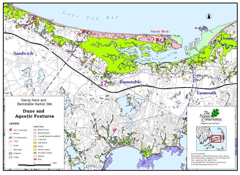
Sandy Neck - MA, U.S.A.
The Sandy Neck/Barnstable Harbor landscape encompasses approximately 6,000 acres on Cape Cod, and includes a high quality barrier beach system and extensive saltmarsh. The project area currently provides habitat for nesting piping plovers (federally threatened) and least terns, as well as feeding habitat for migrating shorebirds.
Priorities and strategies for abatement of invasive plant threats
Measurable goals for reducing invasive species threats and monitoring the success of those efforts
Map: dune and aquatic features
Southern Lake Champlain - VT, U.S.A.
Between the Green Mountains in Vermont and the Adirondack Mountains in New York lies Lake Champlain, the sixth largest lake in the United States. At its southern end, where the lake narrows, is a landscape rich in biodiversity. The Southern Lake Champlain Valley (SLCV) project area covers approximately 400 square miles, and is surprisingly intact ecologically with large blocks of forest, wetland, and lake/river shore still undeveloped.
Measurable goals for reducing invasive species threats and monitoring the success of those efforts
Summit Interlobate Plateau - OH, U.S.A.
The Summit Interlobate Plateau conservation area encompasses almost 350,000 acres in northeastern Ohio. The landscape is dominated by glacial topography, and includes kames, kame terraces, eskers, kettles, kettle lakes, and peatlands. Conservation targets include wetlands, amphibian species assemblages, headwater streams, and fire-dependent oak barrens and savannas.
Measurable goals for reducing invasive species threats and monitoring the success of those efforts
Workshops
Information about the EIN Workshops #1-6, and #7 scheduled to be held in Virginia.
Additional network resources
Web sites and documents related to, produced by, or supporting the Eastern Invasives Network.
The Conservancy's Adirondack Mountains conservation area encompasses roughly the western two-thirds of the six million-acre Adirondack Park in northern New York. This region is a largely unfragmented, forested landscape of spruce-northern hardwood, mountain spruce-fir, and beech-maple-mesic forests. It includes the headwaters of five major drainage basins, 2,800 lakes and ponds, and more than 1,500 miles of rivers.
Priorities and strategies for abatement of invasive plant threats
Measurable goals for reducing invasive species threats and monitoring the success of those efforts
Allegany Forests Project - MD, U.S.A.
The Allegany Forests Project encompasses 150,000 acres in the Central Appalachian Forest Ecoregion. It includes the watersheds of two major tributaries to the upper Potomac River (Sideling Hill and 15-Mile Creeks). The project area includes a matrix forest block (Green Ridge), and incorporates the former Sideling Hill Creek Bioreserve.
Priorities and strategies for abatement of invasive plant threats
Measurable goals for reducing invasive species threats and monitoring the success of those efforts
Invasives inventory
Altamaha River Bioreserve - GA, U.S.A.
The Altamaha River Bioreserve comprises the lower Altamaha River watershed, and falls within the South Atlantic Coastal Plain Ecoregion. It contains a diversity of natural and anthropogenic plant communities, including bottomland hardwood and swamp forests, upland and wetland pine and oak woodlands, and pine plantations. The watershed encompasses over 14,000 square miles, and contains 170,000 acres of floodplain. At almost 90 miles long and up to 6 miles wide, the floodplain of the Altamaha River is one of Georgia's largest contiguous forested wetlands.
Priorities and strategies for abatement of invasive plant threats
Berkshire Taconic Landscape - MA/NY/CT, U.S.A.
The Berkshire Taconic Landscape is a 116,000-acre region of southwestern New York, western Massachusetts, and northern Connecticut. The landscape includes 36,000 acres of matrix forest and a network of high quality calcareous wetlands. Although remarkably pristine, the project area faces two key threats: inappropriate development and the spread of invasive species.
Desired Future Conditions
Ecological Model: Barberry interactions with forest successional patterns
Ecological Model: Impact of Phragmites australis on composition and structure of successional calcareous seepage wetlands.
Priorities and strategies for abatement of invasive plant threats
Map: conservation zones
Map: invasive species across the landscape.
Map: wetlands invaded by Phragmites australis.
Map: Five-year plan for weed removal.
Map: Phragmites australis in Kampoosa bog.
Map: Distribution of Berberis thunbergii.
Camp Shelby - MS, U.S.A.
The Camp Shelby Training Site (CSTS) is a National Guard Training installation located in southern Mississippi in the East Gulf Coastal Plain Ecoregion. The landscape includes rolling, mesic uplands that support longleaf forests; an open understory of scattered oaks and other hardwoods; and a dense, grass-dominated ground cover. Numerous narrow creeks draining the uplands support wetland communities. TNC's Camp Shelby Field Office provides assistance with endangered and threatened species issues on CSTS as contractors for the Mississippi Army National Guard.
Map: overview
Map: conservation targets
Chesapeake Rivers - VA, U.S.A.
The Chesapeake Rivers project area, totaling roughly 1,800 square miles, encompasses the tidal freshwater portions of the Mattaponi, Pamunkey, and lower Rappahannock river systems as well as the non-tidal blackwater river, Dragon Run. These rivers systems are home to some of the most pristine and extensive tidal freshwater marsh and swamp communities remaining in the coastal plain of the Chesapeake Bay, providing unique habitat for the federally listed, globally rare sensitive joint vetch. The marshes also provide critical nursery habitat for native anadromous fishes and nesting grounds for bald eagles, black ducks, king rails and other resident and migratory waterfowl.
Priorities and strategies for abatement of invasive plant threats
Measurable goals for reducing invasive species threats and monitoring the success of those efforts
Delaware River Watershed - PA, U.S.A.
The Delaware River, the longest free-flowing river in the eastern United States, is 331 miles long and unobstructed by dams or other water control structures. The watershed encompasses over 8 million acres in four states. TNC's PA Chapter is currently working at several landscapes in this region, including the Pocono Plateau, Cherry Valley, and Mt. Bethel Fens. Collectively, these sites protect calcareous fen and wetland complexes, seeps, waterfalls, talus slopes, shale cliffs, till barrens, hemlock ravines, rhododendron swamps, and upland forests dominated by oak and northern hardwoods.
Priorities and strategies for abatement of invasive plant threats
Map: overview
Map: Pennsylvania portion of project area
Map: Portfolio sites in PA portion of project area
Map: Current functional sites in PA portion of project area.
Grand Bay Savanna - AL, U.S.A.
Grand Bay Savanna encompasses over 150,000 acres in southeastern Jackson County, MS and southern Mobile County, AL. The project area includes a mosaic of significant wetland areas separated by agricultural/urban uplands.
Map: overview
Hickory Nut Gorge - NC, U.S.A.
Hickory Nut Gorge encompasses roughly 20,000 acres near Asheville, North Carolina on the edge of the Blue Ridge Escarpment in the Blue Ridge physiographic province. The project area supports 14 natural community types, six of which are considered rare. Also present are extensive, high quality examples of common community types that support rare species, including rich cove forest, pine-oak heath, and chestnut oak forest.
Priorities and strategies for abatement of invasive plant threats
Measurable goals for reducing invasive species threats and monitoring the success of those efforts
Indiana Toleston Strandplain - IN, U.S.A.
The Indiana Toleston Strandplain Macrosite is located within the highly industrialized landscape of northern Lake County, Indiana, and includes fragments of the dune and swale topography that characterized the region prior to European settlement. These remnant natural areas continue to support surprisingly diverse biotic communities that are unique to the Great Lakes basin. The project area is approximately 9,000 acres in size, and includes about 1,000 acres of remnant dune and swale.
Kissimmee Valley - FL, U.S.A.
The Kissimmee Valley Landscape Conservation Area occupies approximately 2 million acres in the heart of the Florida
Peninsula Ecoregion, and contains all of the representative natural communities except for coastal communities. The project
area has very high diversity, and contains many rare and endangered species and populations. Ecological Model: Flatwoods matrix
Ecological Model: Lakes
Ecological Model: Kissimmee River tributaries and marshes
Ecological Model: Wetlands
Priorities and strategies for abatement of invasive plant threats
Measurable goals for reducing invasive species threats and monitoring the success of those efforts
Map: overview
Map: restoration project
Milford Neck - DE, U.S.A.
The Milford Neck Conservation Area (MNCA) consists of approximately 10,000 acres of Delaware Bay coastal lands and waters extending north from the Mispillion River to the Murderkill River. Milford Neck contains the entire range of habitat types typically found in coastal areas of the Delaware Bay. These habitats range from high quality beach-dune communities along the shoreline to diverse saltmarsh habitat, narrow-leafed cattail marsh, mixed deciduous swamp forest, loblolly pine forest, mesic mixed upland deciduous forest, and old fields.
Priorities and strategies for abatement of invasive plant threats
Measurable goals for reducing invasive species threats and monitoring the success of those efforts
Quinebaug Highlands - CT, U.S.A.
The Quinebaug Highlands landscape encompasses approximately 172,000 acres in south-central Massachusetts and north-central Connecticut. The project area includes a 34,000-acre block of primary matrix forest that is relatively unfragmented by roads and provides excellent examples of forest types typical of southern New England, including hemlock-northern hardwood, red oak-northern hardwood, and mesic oak.
Measurable goals for reducing invasive species threats and monitoring the success of those efforts
Rolling Fork - KY, U.S.A.
The Salt River/Rolling Fork project area encompasses approximately 500,000 acres in north-central Kentucky. Once a woodland system interspersed with open glades and prairies, the landscape has abundant scattered native stands of tall warm season grasses and forbs, including two federally endangered species. The landscape also includes large blocks of protected forest.
Priorities and strategies for abatement of invasive plant threats
Measurable goals for reducing invasive species threats and monitoring the success of those efforts
Sandy Neck - MA, U.S.A.
The Sandy Neck/Barnstable Harbor landscape encompasses approximately 6,000 acres on Cape Cod, and includes a high quality barrier beach system and extensive saltmarsh. The project area currently provides habitat for nesting piping plovers (federally threatened) and least terns, as well as feeding habitat for migrating shorebirds.
Priorities and strategies for abatement of invasive plant threats
Measurable goals for reducing invasive species threats and monitoring the success of those efforts
Map: dune and aquatic features
Southern Lake Champlain - VT, U.S.A.
Between the Green Mountains in Vermont and the Adirondack Mountains in New York lies Lake Champlain, the sixth largest lake in the United States. At its southern end, where the lake narrows, is a landscape rich in biodiversity. The Southern Lake Champlain Valley (SLCV) project area covers approximately 400 square miles, and is surprisingly intact ecologically with large blocks of forest, wetland, and lake/river shore still undeveloped.
Measurable goals for reducing invasive species threats and monitoring the success of those efforts
Summit Interlobate Plateau - OH, U.S.A.
The Summit Interlobate Plateau conservation area encompasses almost 350,000 acres in northeastern Ohio. The landscape is dominated by glacial topography, and includes kames, kame terraces, eskers, kettles, kettle lakes, and peatlands. Conservation targets include wetlands, amphibian species assemblages, headwater streams, and fire-dependent oak barrens and savannas.
Measurable goals for reducing invasive species threats and monitoring the success of those efforts
Workshops
Information about the EIN Workshops #1-6, and #7 scheduled to be held in Virginia.
Additional network resources
Web sites and documents related to, produced by, or supporting the Eastern Invasives Network.